


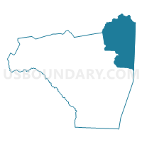
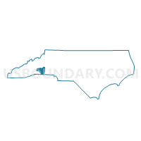
Voting District 10A, Rutherford County, North Carolina
About
Outline

Summary
| Unique Area Identifier | 641363 |
| Name | Voting District 10A |
| County | Rutherford County |
| State | North Carolina |
| Area (square miles) | 85.69 |
| Land Area (square miles) | 85.67 |
| Water Area (square miles) | 0.02 |
| % of Land Area | 99.98 |
| % of Water Area | 0.02 |
| Latitude of the Internal Point | 35.50469380 |
| Longtitude of the Internal Point | -81.75729540 |
Maps

Graphs
Select a template below for downloading or customizing gragh for Voting District 10A, Rutherford County, North Carolina


Neighbors
Neighoring Voting District (by Name) Neighboring Voting District on the Map
- Voting District 0052, Burke County, NC
- Voting District 0053, Burke County, NC
- Voting District 0064, Burke County, NC
- Voting District 03A, Rutherford County, NC
- Voting District 11, Rutherford County, NC
- Voting District CASAR, Cleveland County, NC
- Voting District DYSART, McDowell County, NC
- Voting District POLKVL, Cleveland County, NC
Top 10 Neighboring County Subdivision (by Population) Neighboring County Subdivision on the Map
- Cleveland, Cleveland County, NC (98,078)
- Silver Creek township, Burke County, NC (10,793)
- Colfax township, Rutherford County, NC (8,681)
- Logan Store township, Rutherford County, NC (3,904)
- Dysartsville township, McDowell County, NC (3,450)
- Upper Fork township, Burke County, NC (1,066)
- Golden Valley township, Rutherford County, NC (1,013)
- Duncans Creek township, Rutherford County, NC (594)
Top 10 Neighboring Unified School District (by Population) Neighboring Unified School District on the Map
- Cleveland County Schools, NC (98,078)
- Burke County Schools, NC (90,912)
- Rutherford County Schools, NC (67,810)
- McDowell County Schools, NC (44,996)
Top 10 Neighboring State Legislative District Lower Chamber (by Population) Neighboring State Legislative District Lower Chamber on the Map
- State House District 112, NC (75,804)
- State House District 110, NC (74,293)
- State House District 85, NC (71,855)
Top 10 Neighboring State Legislative District Upper Chamber (by Population) Neighboring State Legislative District Upper Chamber on the Map
- State Senate District 44, NC (173,941)
- State Senate District 47, NC (168,288)
- State Senate District 46, NC (165,888)
Top 10 Neighboring 111th Congressional District (by Population) Neighboring 111th Congressional District on the Map
Top 10 Neighboring Census Tract (by Population) Neighboring Census Tract on the Map
- Census Tract 9709.01, McDowell County, NC (7,429)
- Census Tract 9610, Rutherford County, NC (7,425)
- Census Tract 9601, Rutherford County, NC (6,265)
- Census Tract 9501.01, Cleveland County, NC (5,300)
- Census Tract 213.02, Burke County, NC (3,530)
- Census Tract 9501.02, Cleveland County, NC (2,786)
Top 10 Neighboring 5-Digit ZIP Code Tabulation Area (by Population) Neighboring 5-Digit ZIP Code Tabulation Area on the Map
- 28655, NC (54,996)
- 28150, NC (28,098)
- 28090, NC (8,342)
- 28040, NC (7,969)
- 28018, NC (5,562)
- 28167, NC (2,362)
- 28020, NC (2,322)